Jennings Anderson PhD
Welcome to my node on the net. I'm a Geospatial Information Scientist researching all things OpenStreetMap.
I build full-stack data analysis systems that explore the history and evolution of both the map and the rapidly growing community that collectively maintains the largest free, and open geographic database in the world. I publish summaries of my work on my OSM Diary.
This work started in 2013, originally building new systems to support Crisis Informatics research on the digital convergence of volunteers producing geographic information in support of disaster response and humanitarian aid (Disaster Mapping). I completed my PhD in 2019 in computer science, working with Professors Leysia Palen and Ken Anderson in Project EPIC—a pioneering research lab in the crisis informatics domain. Other research I conducted at The University of Colorado Boulder included collecting and analyzing massive quantities of geo-referenced tweets posted during disasters to learn about protective decision-making practices on social media.
Additionally, I build large-scale Twitter data analysis systems as a Postdoc at CU Boulder. This work is in quick-response to the mis- and disinformation on social media regarding the 2020 Coronavirus Pandemic. This work is now being written about in our new blog, A Post-Mortem of @realDonaldTrump.
This page contains research highlights below. See my CV for a complete listing, or email me at to get in touch.
Selected Works
-
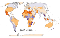
2021 Update on Paid Editing in OpenStreetMap presents country-level OSM paid editing statistics since 2019.

Post-Mortem of @realDonaldTrump is a blog series about on-going research of this phenomenal era in social media.
-
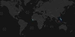
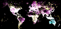
activity.youthmappers.org is an interactive map and dashboard that tracks the growth and mapping coverage of the YouthMappers project.
Latest News
-
March 2021: I was interviewed by Daniel O'Donohue on the Mapscaping Podcast about OpenStreetMap as a "community of communities."
-
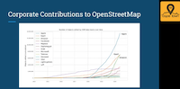
Nov 2020: OpenStreetMap is Having a Moment by Joe Morrison, prominently features our 2019 research on Corporate Editing in OSM.
-
Oct 2020: Our ongoing Twitter research was featured in this Washington Post Article published just before the 2020 US Presidential Election: The unseen machine pushing Trump’s social media megaphone into overdrive
Selected Talks (Videos)

Selected Publications

See my CV for a complete list, or email me at to get in touch.